VIVEK DHAKAL
Objectives & Methods of River Training Works

Objectives & Methods of River Training Works

Definition of River Training

The process of controlling the flow in river & river bed configuration is called river training works. These are the structural measures adopted in rivers to avoid outflanking & shifting its thalweg due to geomorphological changes in the river. So, the river training works stabilize the river channel along a certain alignment.
Methods of Soil Compaction | Types of Soil Compaction

Methods of Soil Compaction | Types of Soil Compaction

Methods of soil compaction
Compaction of soil is necessary for various types of foundations used in civil engineering constructions. It improves the engineering properties of soil. Compaction is the process of reducing air voids in soil by means of mechanical compressions. During compaction, the air is expelled from the voids in the soil. It increases the dry density of soil, improves shear strength & hence stability and bearing capacity. The various methods of soil compaction are as follows:
  • Tamper / Rammer
    • Hand Operated Tamper
    • Mechanical Tamper
  • Roller
    • Smooth Wheeled Roller
    • Pneumatic Tyred Roller
    • Sheep Foot Roller
  • Vibrator
Types of Foundation Used in Civil Engineering Constructions

Types of Foundation Used in Civil Engineering Constructions

Every civil engineering structure, whether it is a building, a bridge, or a dam, is founded on or below the surface of the earth. Foundations are required to transmit the load of the structure to the foundation soil safely & efficiently. Different types of foundations used in civil engineering constructions can be classified as follows:
Types of foundations used in Civil Engineering constructions

Shallow Foundation

According to Terzaghi, a shallow foundation is one whose width is greater than its depth. i.e. Df/B<1. Such a foundation transmits the load to the upper strata of the earth & is generally provided to the lightweight structures. It is preferred when foundation soil has sufficient bearing capacity at shallow depth. When the sum of areas covered by each isolated footings is more than 50% of the total area of the foundation, mat foundation is adopted.

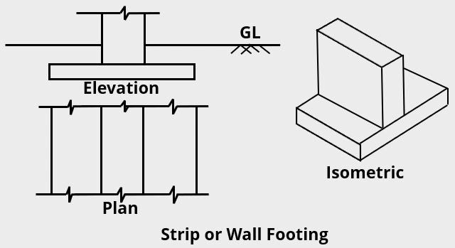
Strip or Wall Footing

Strip or Wall Footing

Isolated or Spread Footing

Isolated or Spread footing used in Civil Engineering constructions

Combined Footing

Combined footing used in Civil Engineering constructions

Strap or Cantilever Footing

Strap footing or cantilever footing

Mat or Raft Foundation

Types of Mat or Raft Foundation

Deep Foundation

A deep foundation is one whose width is less than its depth i.e. Df/B>1. Such a foundation transmits the load to the strata at a considerable depth below the surface of the earth & is provided to the heavyweight structure. It is preferred when the soil at the surface of the earth does not possess a considerable bearing capacity. The most common types of deep foundations are piles, piers & caissons. Well foundations are the special case of open caissons.
Types of deep foundation used in civil engineering constructions
What are the Criteria for Selection of Ideal Bridge Site?

What are the Criteria for Selection of Ideal Bridge Site?

Criteria for selection of ideal bridge site
It is necessary to select an ideal bridge site at which the bridge can be made economically. As construction of a bridge requires a heavy investment, the bridge site should be selected wisely. A poor bridge site may increase the project's cost, making it susceptible to damage, in the long run, thus decreasing the life span of bridges. Thus, the following are the factors that require attention while selecting a bridge site.
Principles & Techniques of Bioengineering for Civil Engineers

Principles & Techniques of Bioengineering for Civil Engineers

In a broader sense, Bioengineering is the use of life science & engineering to solve human life problems. Here, in this article, we are using the term bioengineering in the context of civil engineering & it basically refers to soil bioengineering. So, Bioengineering can be defined as the use of vegetative measures & small civil engineering structures in order to reduce the shallow seated instability. The living plants or non-living plant materials are used alone or in conjunction with small civil engineering structures for slope stabilization & erosion control. It utilizes locally available resources & is a cost-effective method.

Principles of Bioengineering

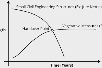
Initially, stability is obtained from the small civil engineering structures. The strength of those structures decreases gradually. After the handover point, stability is derived from the vegetative measures. This can be depicted from the graph shown below:
Principles of Soil Bioengineering

Functions of Bioengineering

Engineering functions performed by vegetation on a slope are as follows:
  • Catch
  • Armor
  • Reinforce
  • Anchor
  • Support
  • Drain

Advantages of Bioengineering

  • Immediate slope stabilization & erosion control
  • Utilization of locally available resources (local tools, local manpower, local materials)
  • It is a cost-effective method
  • No need for frequent maintenance
  • It also provides an opportunity for wildlife habitat
  • It also improves the aesthetic beauty of the site

Commonly Used Techniques of Bioengineering

  • Fascine: Bundle of live branches laid in shallow trenches
  • Palisade: Woody cuttings planted across the slope.
  • Wattling: Fence made out of vegetative materials.
  • Bamboo Planting: Planting of bamboo for soil conservation
  • Grass Planting: Planting of grass across the slope
  • Brush Layering: Layers of woody cuttings planted in line following the contour
  • RipRap: Stone pitching with vegetation interplanted between them
  • Retaining Wall: Wall built to resist the pressure of earth filling or backing
    • Toe Wall
    • Breast Wall or Revetment Wall
  • Check Dam: Dams constructed across the gullies to retard the flow
  • Gabion Wall: Walls made up of gabion wire filled with stones
  • Stone Masonry: Masonry construction using stones & mortar 
  • Jute Netting: Protecting the slope with standard jute mesh
  • Rock Netting: Wire mesh of reliable material used to control the rockfall
  • Rock Bolting: Reinforcement of rock slope by inserting steel bars
  • French Drain: Subsurface drainage channel filled with aggregates
Degree of Static & Kinematic Indeterminacy of Structures

Degree of Static & Kinematic Indeterminacy of Structures

A structural system that can be analyzed by using the equation of static equilibrium only is called statically determinate structure i.e. reaction components and internal stresses can be calculated using static equilibrium equations only. Eg: Simply supported beam. If it cannot be analyzed by the equation of static equilibrium alone, then it is called a statically indeterminate structure. Eg: Fixed beam. A structural system is said to be kinematically indeterminate if the displacement components of its joints cannot be determined by the compatibility equation alone. Eg: Simply supported beam. If those unknown quantities can be found by using compatibility equations alone then the structure is called kinematically determinate structure. Eg: Fixed beam. But before calculating the degree of indeterminacy of a structure, it is good to know about its stability. If a structure is unstable, then it doesn't matter whether it is statically determinate or indeterminate. In all cases, such types of structures should be avoided in practice.
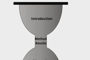
Parts of Research Paper | How to Write a Research Paper?

Parts of Research Paper | How to Write a Research Paper?

How to write a Research Paper?

A research paper is scientific writing that shapes up an idea into words with solid and verifiable evidence. The main goal of a research paper is to assemble different opinions, perspectives, corroboration, and facts on a subject matter from various resources like articles, books, other research papers, interviews and elucidate the details and findings in one's own words. The most popular types of research papers are argumentative papers, analytical papers, definition papers, compare and contrast papers, cause and effect papers, reports, and interpretive papers.

Federal Nepal: Provinces & Local Levels of Nepal

Federal Nepal: Provinces & Local Levels of Nepal

According to article 56 of the constitution of Nepal, the main structure of the federal democratic republic of Nepal shall be of three levels namely the federation, the state & local levels. As per the present constitution, Nepal has 7 states/provinces & 753 local levels. The new structure divides Nepal into 77 districts & 6,743 wards. The local levels include metropolises (6), sub metropolises (11), municipalities (276) & gaupalikas (460).
New Map of Nepal with 7 provinces and their Capitals

The capital city of Nepal is Kathmandu. The current President of Nepal is Bidhya Devi Bhandari & the current prime minister is Sher Bahadur Deuba. Nepal has a total population of  2,64,94,504 according to the 2011 census.

7 States of Nepal

Province No 1

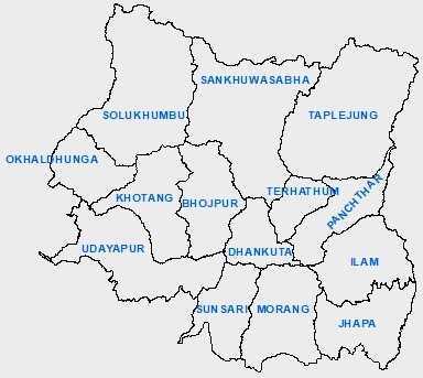
Map of Province no 1 with districts
Province no 1 lies in the eastern region of Nepal. Its boundary touches both of the neighboring countries of Nepal i.e. India & China. It consists of 14 districts & 137 local levels. Mount Everest, the highest peak of the world is located in this state. Apart from this, it has other mountains like Kanchanjangha, Choyu, Makalu, Lotse, etc. Illam, Namche Bajar of Solukhumbu, Sagarmatha base camp, etc are the major tourist attractions of this region. The famous Pathivara temple of Taplejung district is also located in this state. The Puwa Khola hydroelectricity project & Thame hydroelectricity project are situated in this state. The major rivers of this province are Mechi, Arun, Tamor, Dudhkoshi, etc. The major lakes located in this province are namely Mai Pokhari, Jor Pokhari, Baraha Lake, etc.

Province No 2: Madhesh Pradesh

Map of Province no 2 with districts
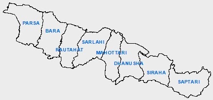
It is the smallest state of Nepal & only touches India in its boundary. It has 8 districts along with 136 local levels. The Janaki temple of Janakpur & Chhinamasta temple of Saptari district are the major religious places of this state. The well-known Bagamati irrigation project lies in this province. This is the only province of Nepal that does not contain any hydroelectricity project. The biggest river of Nepal, the Saptakoshi river flows in this region.

Province No 3: Bagmati Pradesh

Map of Province no 3 with districts
It is a relatively more developed & well-infrastructured province of Nepal. It has its border connected to both India & China. The capital city of the country, Kathmandu, is situated in this province & the provincial capital is Hetauda. Kathmandu city is also known as the city of temples. The Pashupatinath Temple, Krishna temple of Patan, Swyambhunath, Bouddhanath, Changunarayan, Gosaikunda, Kalinchowk Bhagwati, Manakamana temple, Dakshinkali temple, etc are the major religious places of this state. There are other well-known tourist attractions as well. They are namely Patan, Bhaktapur, Nagarkot, Chovar, Dhulikhel, Chitwan National Park, Langtang National Park, Shivapuri Nagarjun National Park, Chandragiri hills, Annapurna base camp trekking, etc. This province consists of 13 districts & 119 local levels.

Province No 4: Gandaki Pradesh

Map of Province no 4 with districts
Gandaki Province is situated in between Province no 5 & Bagmati Province touching both of the neighboring countries at its boundary. It consists of 11 districts along with 85 local levels. The Pokhara city, also called tourists paradise, is located at the heart of this state. The heavenly Pokhara city, Phewa Lake, Devi's Fall, Mahendra Cave, International Mountain Museum, Annapurna Mountain, Machapuchre Mountain, Tilicho Lake, Upper Mustang, etc are the major tourist attractions of this state. Kaligandaki, Budigandaki, Marsyandi, Modi, Seti, Aandhikhola etc are the major rivers flowing in this state.

Province No 5: Lumbini Pradesh

Map of Province no 5 with districts
Province No 5 is one of the 7 provinces established by the present constitution of Nepal that contains 6 districts in the Terai region and the remaining 6 districts in the mountainous region out of a total of 12 districts within its territory. It only touches India at its boundary. Lumbini, the birthplace of Lord Gautam Buddha is situated in this state. The largest valley of Asia i.e. the Dang valley lies in this region. Lumbini, Bardiya National Park, Banke National Park, Blackbuck Conservation area, etc are the major tourist attractions of this province.

Province No 6: Karnali Pradesh

Map of Province no 6 with districts
It is the largest state of Nepal that only touches China in the North at its boundary. It has 10 districts & 79 local levels. Humla Karnali, Mugu Karnali, Thulo Bheri, Sano Bheri, Budiganga, Setiganga, Tila, etc are the major rivers of this region. Rara lake, Shey Phoksundo lake, Syarpu lake, Jagadulla lake, Bulbule lake, etc are the well-known lakes of this state. Rara National Park, Shey Phoksundo National Park, Kankrebihar, etc are well-known sites for tourists attraction in this region.

Province No 7: Sudur Pashchim Pradesh

Map of Province no 7 with districts
It is situated at the western end of Nepal & touches both India and China at its boundary. It consists of 9 districts & 88 local levels. Kailali, Tikapur, Mahendranagar, Dhangadhi, etc are the main cities of this state. Khaptad National Park, Shuklaphata National Park, Naini Lake, Jhilamila Lake, Ghodaghodi Lake, Dodhara Chadhani bridge, Karnali bridge, Tikapur Park, Lipulekh, Limpiyadhura, Kalapani, etc are the major tourist destinations of this region. The Mahakali river flows in this state.

Local Levels of Nepal

A total of 753 local levels have been made in the new federal structure of Nepal. They comprise 6743 wards. The local levels include gaupalikas, metropolis, sub metropolis & municipalities. Kathmandu & Bhaktapur districts do not have gaupalikas. Likewise Manang, Mustang, Humla, Rauwa & Purbi Rukum districts do not have municipalities. All the local levels of Nepal operate under the Local Government Operation Act, 2074 which came into effect in 2074/06/29. This act has made a criterion of 5 - 21 wards limit for Gaupalikas & 9 - 35 wards limit for municipalities.
National Parks of Nepal | Wildlife Reserve and Conservation Areas

National Parks of Nepal | Wildlife Reserve and Conservation Areas

12 National Parks of Nepal in map

National Parks

  1. Parsa National Park
  2. Shukla Phanta National Park
  3. Banke National Park
  4. Shivapuri Nagarjun National Park
  5. Makalu Barun National Park
  6. Khaptad National Park
  7. Shey-Phoksundo National Park
  8. Bardiya National Park
  9. Rara National Park
  10. Langtang National Park
  11. Sagarmatha National Park
  12. Chitwan National Park

Wildlife Reserve

Koshitappu Wildlife Reserve is the only one wild life reserve of Nepal established in 2032 BS with a aim to protect particular group of flora and fauna. In 1987, Koshi Tappu was declared a Ramsar site, a wetland of international significance.

Hunting Reserve

Dhorpatan Hunting Reserve is the only hunting reserve in Nepal established in 2044 BS with an aim of preserving a representative high altitude ecosystem in west Nepal and allow sports hunting of blue sheep and other game animals.

Conservation Areas

  1. Krishnasaar Conservation Area
  2. Api Nanpa Conservation Area
  3. Gaurishankar Conservation Area
  4. Manaslu Conservation Area
  5. Kanchanjunga Conservation Area
  6. Annapurna Conservation Area
Hydroelectricity in Nepal | Hydropower Projects in Nepal

Hydroelectricity in Nepal | Hydropower Projects in Nepal

Hydroelectricity in Nepal

There are more than 6000 rivers with a total reach length of 45000 km flowing in our country. They occupy about 3.9 % of the total land of Nepal. The snowy mountains & glacier lakes are also our major water resources. This makes Nepal be the second richest country in water resources after Brazil in the world. Nepal contains 2.27% water of the total water resource in the world. Due to such resources, we have a huge potential for hydropower production which is theoretically found to be 83000 MW. Out of this, 42000 MW of hydroelectricity is feasible economically & technically.