VIVEK DHAKAL: Engineering
Degree of Static & Kinematic Indeterminacy of Structures

Degree of Static & Kinematic Indeterminacy of Structures

A structural system that can be analyzed by using the equation of static equilibrium only is called statically determinate structure i.e. reaction components and internal stresses can be calculated using static equilibrium equations only. Eg: Simply supported beam. If it cannot be analyzed by the equation of static equilibrium alone, then it is called a statically indeterminate structure. Eg: Fixed beam. A structural system is said to be kinematically indeterminate if the displacement components of its joints cannot be determined by the compatibility equation alone. Eg: Simply supported beam. If those unknown quantities can be found by using compatibility equations alone then the structure is called kinematically determinate structure. Eg: Fixed beam. But before calculating the degree of indeterminacy of a structure, it is good to know about its stability. If a structure is unstable, then it doesn't matter whether it is statically determinate or indeterminate. In all cases, such types of structures should be avoided in practice.
Parts of Research Paper | How to Write a Research Paper?

Parts of Research Paper | How to Write a Research Paper?

How to write a Research Paper?

A research paper is scientific writing that shapes up an idea into words with solid and verifiable evidence. The main goal of a research paper is to assemble different opinions, perspectives, corroboration, and facts on a subject matter from various resources like articles, books, other research papers, interviews and elucidate the details and findings in one's own words. The most popular types of research papers are argumentative papers, analytical papers, definition papers, compare and contrast papers, cause and effect papers, reports, and interpretive papers.

Hydroelectricity in Nepal | Hydropower Projects in Nepal

Hydroelectricity in Nepal | Hydropower Projects in Nepal

Hydroelectricity in Nepal

There are more than 6000 rivers with a total reach length of 45000 km flowing in our country. They occupy about 3.9 % of the total land of Nepal. The snowy mountains & glacier lakes are also our major water resources. This makes Nepal be the second richest country in water resources after Brazil in the world. Nepal contains 2.27% water of the total water resource in the world. Due to such resources, we have a huge potential for hydropower production which is theoretically found to be 83000 MW. Out of this, 42000 MW of hydroelectricity is feasible economically & technically.
Public Private Partnership | PPP in Nepal

Public Private Partnership | PPP in Nepal

Public Private Partnership in Nepal
Public Private Partnership (PPP, 3P, or P3) is a frequently pronounced term in the field of infrastructure development & contract management. It is a widely adopted model mainly for public service delivery. So, before diving into the concept of public private partnership, it is good to know about public service delivery & the various options available for it.
Watershed & Watershed Delineation | Calculating Catchment Area

Watershed & Watershed Delineation | Calculating Catchment Area

What is Watershed & Watershed Delineation?

A watershed is all the land & water which contributes runoff to a common point or outlet point. It is also called a catchment or drainage area. The terms catchment & watershed are found to be used interchangeably. So, the watershed area is the land area, from where all the surface runoff converges to a single point to give common discharge. Watershed delineation thus refers to creating a boundary that represents the contributing area for a particular outlet point.

Method of Watershed Delineation

Why Watershed Delineation is required?

Watershed delineation is done primarily to define the boundary of the study area or to divide the study area into subareas. Also, watershed delineation is the initial job for calculating catchment area. So, watershed delineation has major importance in watershed management, soil conservation & hydrometeorological studies.

How to delineate watershed?

Delineating watershed means you're drawing boundary lines of the catchment on a map. Traditionally, this is done manually in the topographic maps using information from contours but some digital methods are also available nowadays. Watershed delineation can be done by following different methods:
  1. Topo Map Method
  2. Google Earth Pro Method
  3. GIS Method
While dealing with the topo map method, one should have sound knowledge of contour lines & map scale. We should be able to visualize the terrain by seeing the contour lines. We should find where ridge & valley exists and also note that the flow direction is always perpendicular to the contour line. Here are few steps for watershed delineation & calculation of catchment area from topo map:
  • Mark the outlet point in the topo map
  • Starting from the outlet point, draw lines perpendicular to the contours in such a way that the line passes through the ridges
  • Following the procedure, connect all the possible extreme points whose discharge converges into the outlet & finally, end at the outlet point.
  • After demarcation of the catchment boundary in the topo map, trace the delineated area in transparent graph paper. Count the number of squares in the graph paper that the catchment has covered & keeping in mind of map scale, determine the value of the catchment area.
                    As an alternative to this graph paper method, we can use Autocad to calculate the catchment area. For this, scan the topo map catchment & import it to the Autocad environment. Fix the scale of the imported image & retrace the catchment boundary in Autocad using polylines. Now, the area of a polygon can easily be determined in Autocad.

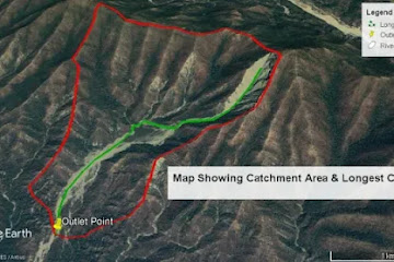
Google earth pro method for watershed delineation is quite famous nowadays. Using Google earth pro, we can visualize our catchment in 3D & draw the catchment boundary as a polygon by eye judgment & instantly, Google earth pro shows you the area covered by polygon in the required unit.

GIS method of watershed delineation is the most accurate among all mentioned here. While using GIS for watershed delineation & determination of catchment area, we need DEM data of study area. The DEM data is then loaded in ArcGIS & different tools are available in ArcGIS in order to delineate watershed & determine the corresponding area. Here, ArcGIS automatically delineates the catchment for you once you provide correct information to it. One can download the DEM data directly from USGS Earth Explorer for free & can proceed further in ArcGIS.
Monthly Flow Estimation | Regional & Empirical Methods in Nepal

Monthly Flow Estimation | Regional & Empirical Methods in Nepal

Monthly flow estimation of a catchment is a major task for the design of an irrigation system in a required commanded area. We generally estimate runoff as annual or monthly flow, extremely low flow & flood flow. Annual or monthly flow is required for the design of irrigation water requirements whereas extreme low flow & flood flow are determined for the design of hydraulic structures & river training works. Here, in this article, we are mainly concerned with the estimation of monthly flow in the catchment area of study. When long-term flow data of the study are available, we use the frequency analysis method. In absence of such records, we can apply regional & empirical methods to calculate monthly flows.
Design Flood Estimation | Regional & Empirical Methods in Nepal

Design Flood Estimation | Regional & Empirical Methods in Nepal

Most of the hydrological designs consider extreme flood flows. Like, in the design of hydraulic structures such as dams, weirs, barrages, bridges, etc one needs maximum flood discharge as well as maximum flood levels. Thus, design flood estimation is a major task for the design of hydraulic structures & river training works. The estimation of runoff from a catchment is a very complex problem. Runoff is generally estimated in the following different forms: