VIVEK DHAKAL
Importance & Requirements of Highway Drainage

Importance & Requirements of Highway Drainage

Water has detrimental effects on the good performance of road & should be drained off as soon as possible. The process of quick removal of water out of surface & sub-surface region of the road is called Highway Drainage. The surface & sub-surface water of the road should quickly pass into the longitudinal drains if a proper highway drainage system is present. The surface water passes into longitudinal drains via gravity flow due to the cross-slope provided on the road surface. The subsurface water first goes into the perforated cross drains & then into the longitudinal drains, both being under the road surface in the areas of heavy rainfall. The surface drainage system prevents the surface water from percolating down to the sub-surface layers. The sub-surface drainage system takes the sub-surface water out of the subsurface layers.

What is the Importance of Highway Drainage?

The provision of a proper drainage system provides the following important functions:
  1. It arrests the moisture variation in the subsurface layers thus preventing the reduction in bearing capacity of subgrade soil.
  2. It prevents the erosion of side slopes.
  3. It prevents the failure of formation slope caused by the poor drainage system.
  4. It prevents the stripping of bitumen from aggregates in flexible pavements.
  5. It prevents the mud pumping in rigid pavements.
  6. It prevents the skidding of vehicles caused by a reduction in friction coefficient.
  7. It prevents the frost action caused by the accumulation of water.

What are the Requirements of a Good Highway Drainage System?

A good highway drainage system should fulfill the following requirements:
  1. The surface water on the carriageway and shoulder should be drained off effectively as soon as possible.
  2. The surface water from the adjoining land should be prevented from entering into the roadway.
  3. The groundwater table should be maintained well below the bottom surface of the subgrade soil.
  4. The capillary rise & seepage water should be controlled effectively.
  5. The longitudinal drains & cross drains should have sufficient capacity to carry the collected water.
  6. The longitudinal drains & cross drains should have sufficient bed slope for gravity flow.
  7. The flow of water across the road surface & in the drains should not cause erosion.
  8. Complex & costly cross drainage structures should be avoided as much as possible.
Road Classification in Nepal | Nepal Road Standard 2070

Road Classification in Nepal | Nepal Road Standard 2070

Roads in Nepal are classified according to different guidelines & standards developed by the government of Nepal. The major guidelines are Nepal Road Standard 2070 (NRS 2070), Nepal Rural Road Standard 2071 (NRRS 2071), Nepal Urban Road Standard 2076 (NURS 2076), etc.

Nepal Road Standard 2070

According to Nepal Road Standard 2070, the roads in Nepal can be classified as follows:
  • Administrative Classification
    • National Highways
    • Feeder Roads
    • District Roads
    • Urban Roads
  • Technical/Functional Classification
    • Class I
    • Class II
    • Class III
    • Class IV

Administrative Classification

Administrative classification of roads is intended to assign national importance & level of government responsible for the overall management and financing methods.
1. National Highways
These are the major roads running east to west & north to south of the country.
2. Feeder Roads
These are the roads connecting the district headquarters, major economic centers & tourism centers to national highways or other feeder roads.
3. District Roads
These are the roads within a district, serving areas of production & markets, and connecting with each other & with the main highways.
4. Urban Roads
These are the road within an urban municipality.

In Nepal, the overall management of national highways & feeder roads comes under the responsibility of the Department of Road (DOR). And these roads are collectively called Strategic Road Network (SRN). The district roads & urban roads fall under the responsibility of the Department of Local Infrastructure Development & Agricultural Roads (DOLIDAR). And these roads are collectively called Local Road Network (LRN).

Technical / Functional Classification

Road Classification in Nepal

Nepal Rural Road Standard 2071

According to Nepal Rural Road Standard 2055, 2nd revision 2071, the rural roads in Nepal are classified as below:
  • District Road Core Network (DRCN)
  • Village Road
1. District Road Core Network (DRCN)
It is an important road joining a VDC HQ's office or nearest economic center to the district headquarters, via either a neighboring district headquarters or the Strategic Road Network.
2. Village Road
Smaller roads not falling under District Road Core Network category are Village Roads, including other Agricultural Road.

Nepal Urban Road Standard 2076

According to Nepal Urban Road Standard 2076, the urban roads are classified as follows:
  • Arterial Roads (Path)
  • Sub-arterials Roads (Sadak)
  • Collector Roads (Marg)
  • Local Roads (Upa-Marg)
1. Arterial Roads (Path)
These are the roads generally meant for through traffic usually on a continuous route.
2. Sub-arterial Roads (Sadak)
These are the roads of the somewhat lower levels of travel mobility than the arterial roads.
3. Collector Roads (Marg)
A collector road is one intended for collecting & distributing traffic to and from local roads & also providing the access to arterial/sub-arterial roads.
4. Local Roads (Upa-Marg)
A local road is one primarily intended for access to the residence, business, and other abutting property.
What are the Special Considerations for Hill Road Alignment?

What are the Special Considerations for Hill Road Alignment?

What is Hill Road?

According to Nepal Rural Road Standards (2055), 2nd Revision 2071, the terrain is classified as Terai & Hills based on the topography of the country. The Terai covers the plain & rolling terrain having a cross slope of 0 to 25%. Hill covers the mountainous & steep terrain having a cross slope of 25 to 60% and more. The road passing through the hilly terrain with a cross slope of 25% or more is generally termed as Hill Road. A hill road usually consists of either a river route or a ridge route.

Factors affecting alignments of hill roads

What are the Factors Affecting the Alignment of Hill Roads?

There are various factors affecting road alignment. Moreover, there are some special considerations to be followed while selecting a hill road alignment. The major factors to be considered while deciding the alignment of hill roads are as follows:

1. Geological Stability

The road alignment should pass through a stable hill slope. The area should not be prone to erosion, landslides, rockfall, etc.

2. Availability of Construction Materials

Availability of construction materials near the construction site will reduce the transportation cost of materials thus making the project economical.

3. Cross Drainage Structures

Due to numerous watercourses present in the hilly regions, there may be the necessity of intense cross drainage works. The alignment should be so selected in such a way that the number of cross-drainage structures required becomes minimum.

4. Geological Structures

Excessive cutting of hard rock will be expensive. So, such areas should be avoided as much as possible from the road alignment.

5. Geometric Design

The alignment should be chosen to minimize the ineffective rise & fall, steep gradients, number of hairpin bends, etc. Also, the geometric design parameters should comply with the design guidelines & standards for hilly regions.

6. Altitude of the Road

  • Rainfall (or Snowfall) ∝ Altitude
  • Atmospheric Pressure ∝ $\frac{1}{Altitude}$
  • As the altitude decreases, the number of cross drainage works required increases.
Basics of Tunnel Engineering | Methods of Tunnelling

Basics of Tunnel Engineering | Methods of Tunnelling

Methods of tunneling in Civil Engineering

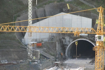
Tunnels are underground passages used for transportation purposes. Tunnels are the underground routes driven without disturbing the overlying soil to bypass the obstacles safely. Tunnels can be used to carry passengers & freights, water, sewers, gases, etc. Tunnels are constructed in various shapes & sizes. The shape of the tunnel cross-section is governed by the nature & type of ground to be penetrated, existing overburden stress on the rock, etc while the size of the tunnel depends on the usage to which it is subjected. The economy of tunnel construction depends on the relative cost of open cuts vs. tunnelling. The tunnel becomes more economical than an open cut beyond a certain depth.

Advantages of Tunnelling

  • It reduces the route distance & travel time
  • It provides easy gradients in hilly terrain
  • Surface activities are not disturbed
  • It remains free from the weather actions like rainfall, snow, etc.
  • The tunnel becomes more economical than an open cut beyond a certain depth.

Disadvantages of Tunnelling

  • The initial cost of construction may become higher
  • Construction of tunnel requires skilled manpower & sophisticated equipment
  • Strick supervision is necessary during construction
  • Higher safety precautions are necessary during construction
  • Construction of tunnel requires more time than open cuts
  • A tunnel may collapse during an earthquake

Terminologies related to Tunnel Engineering

  • Tunnel Portal: It is the entrance or exit of tunnel where tunnel intersects with the open area. It may be an inlet portal or outlet portal.
  • Crown: It is the topmost point of the tunnel cross-section.
  • Invert: It is the lowest point of the tunnel cross-section.
  • Faces of Operation or Attack: It is the surface from which a boring operation is carried out.
  • Adit Tunnel: It is a horizontal or near-horizontal passage that provides access for extra faces of operation/attack in addition to the inlet face and outlet face. It may also be used for the purpose of the auxiliary entrance, ventilation, drainage, etc.
  • Inclined/Vertical Shaft: It is an inclined or vertical passageway that connects the surface to the underground tunnel or network of tunnels.
  • Pilot Tunnel: It is a small tunnel driven, parallel & close to the proposed main tunnel, to explore geological conditions & assist in final excavation. During construction of vertical shaft, a pilot tunnel is excavated at first.
  • Tunnel Linings: These are the supports erected during & after tunnel construction to ensure a safe working environment inside the tunnels. Rock bolts, steel ribs, wire mesh, shotcrete, etc are used as tunnel lining materials.
  • Mucking: Mucking means the removal of blasted debris from the tunnel interior to a good distance outside the tunnel entrance.
  • Overbreak: It is the over excavation beyond the intended boundaries, resulting in a larger opening or void than originally intended.
  • Niche: It is the relatively small recesses or compartments excavated inside a tunnel for specific purpose such as equipment housing, utility installation, for vehicles to make turns or change direction, etc.
  • Cavern: Caverns are intentionally excavated larger underground chambers for construction of specific underground structure such as an underground powerhouse. In tunnelling, niches and caverns are both types of excavated spaces within the tunnel structure, but they differ in terms of size, purpose, and construction methodology.
  • Grouting: Grouting is a process where a fluid material, often cement-based, is injected into the ground to improve soil or rock properties.
  • Overburden: Overburden refers to the soil, rock, or other material that lies above the tunnel roof or crown.

A. Based on Purpose

  1. Traffic Tunnel
    • Highway Tunnel
    • Railway Tunnel
    • Pedestrian Tunnel
  2. Conveyance Tunnel
    • Power Tunnel
    • Water Supply Tunnel
    • Sewer Tunnel

B. Based on Shape/Cross-Section

  1. Circular Tunnel
  2. D Shaped Tunnel
  3. Horse Shoe Tunnel
  4. Square or Rectangular Tunnel
  5. Elliptical Tunnel

Methods of Tunnelling

During tunnel construction, tunnels are lined with suitable materials parallelly with the boring operations. Tunnels are usually lined with timber, steel, cast iron, masonry, or concrete with suitable outlets to let out the enclosed subsoil water behind the linings. Other items of work include the provision of ventilation, drainage, lighting, etc. Tunnelling may have to be done in the hard rock or soft soil based on which the method of tunnelling differs. Hard rock is considered as a fully self-supporting soil that does not require much support except where a loose rock is occasionally met. On the other hand, soft soils like running grounds (eg: water-bearing sands) require instant supports all around. So, different methods of tunnelling based on the nature of the soil to be penetrated are listed below:

A. Tunnelling in Soft Ground

  1. Fore Poling Method
  2. Needle Beam Method
  3. Shield Method
  4. Compressed Air Method
  5. Liner Plate Method
  6. Army Method
  7. American Method

B. Tunnelling in Hard Rock

  1. Full Face Method
  2. Top Heading Benching
  3. Bottom Heading & Stopping
  4. Drift Method
  5. Pilot Tunnel Method
For the detailed description of each method of tunnelling listed above, the readers are kindly requested to go through ref 1.

References
  1. Srinivasan, R.(1958). Harbour, dock and tunnel engineering. India: Charotall Book Stall
What are the Factors Controlling Highway Alignment?

What are the Factors Controlling Highway Alignment?

What is Highway Alignment?

The process of establishing the centerline of a road is called highway alignment or Road alignment. It the direction through which the highway will pass. Highway alignment can be divided into two parts as Horizontal Alignment & Vertical Alignment. The horizontal alignment is seen in the plan of the road & it consists of the straight path, horizontal curves, etc. The vertical alignment is observed in the longitudinal profile of the road & it contains verticle curves, gradients, etc.

What are the Requirements of Highway Alignment?

An ideal highway alignment may fulfill the following criteria:
  • Short: The route between any two points should be the shortest route.
  • Safety: The alignment should satisfy the safety requirements.
  • Comfort: The alignment should have easy curves & gradients.
  • Economy: The cost of construction should be economic.

What are the Factors Controlling Highway Alignment?

There are various factors to be considered while selecting a road alignment. Additionally, there are some special considerations to be followed while selecting alignments in hill roads. In general, the following factors are to be considered while choosing a highway alignment.

1. Government Plannings

Since a road project involves heavy investments, it should comply with government requirements & planning.

2. Obligatory Points

Obligatory points are the governing points that control the highway alignment. These can be classified into two types viz. the points thorough which alignment should always pass (or positive obligatory points) & the points through which the alignment should never pass (or negative obligatory points). Ex: Highway alignment should always pass through the bridge site. In the case of mountains in the alignment, there may be options either to go round the hill or to construct a tunnel. Moreover, the highway alignment should never pass through the National Parks, Conservation Areas, Protected Areas, dense forest, costly agricultural lands, etc. In the case of an intermediate town, the highway alignment may get deviated slightly in order to connect the town.

3. Traffic Flow Pattern

The traffic flow pattern can be known from the origin & destination study (O&D Study). The lines are drawn in the data obtained from the origin & destination study & then, proper alignment is fixed.

4. Geometric Design

The road alignment is also affected by the geometric design. The horizontal curves, vertical curves, gradients, sight distance, etc should meet the requirements of geometric design standards.

5. Monotony

Due to very long straight paths in flat terrain, the driver may become monotonous & this may lead to accidents. Thus, small horizontal curves should be provided in suitable intervals to avoid monotony.

6. Economy

The alignment should be selected in such a way that the construction cost, maintenance cost & operation cost of the road is minimum. Excessive cuttings & fillings, the necessity of complex structures, etc should be avoided.

7. Railway Crossings

A highway alignment should cross the railway alignment preferably at a right angle.
Objectives & Methods of River Training Works

Objectives & Methods of River Training Works

Definition of River Training

The process of controlling the flow in river & river bed configuration is called river training works. These are the structural measures adopted in rivers to avoid outflanking & shifting its thalweg due to geomorphological changes in the river. So, the river training works stabilize the river channel along a certain alignment.
Methods of Soil Compaction | Types of Soil Compaction

Methods of Soil Compaction | Types of Soil Compaction

Methods of soil compaction
Compaction of soil is necessary for various types of foundations used in civil engineering constructions. It improves the engineering properties of soil. Compaction is the process of reducing air voids in soil by means of mechanical compressions. During compaction, the air is expelled from the voids in the soil. It increases the dry density of soil, improves shear strength & hence stability and bearing capacity. The various methods of soil compaction are as follows:
  • Tamper / Rammer
    • Hand Operated Tamper
    • Mechanical Tamper
  • Roller
    • Smooth Wheeled Roller
    • Pneumatic Tyred Roller
    • Sheep Foot Roller
  • Vibrator
Types of Foundation Used in Civil Engineering Constructions

Types of Foundation Used in Civil Engineering Constructions

Every civil engineering structure, whether it is a building, a bridge, or a dam, is founded on or below the surface of the earth. Foundations are required to transmit the load of the structure to the foundation soil safely & efficiently. Different types of foundations used in civil engineering constructions can be classified as follows:
Types of foundations used in Civil Engineering constructions

Shallow Foundation

According to Terzaghi, a shallow foundation is one whose width is greater than its depth. i.e. Df/B<1. Such a foundation transmits the load to the upper strata of the earth & is generally provided to the lightweight structures. It is preferred when foundation soil has sufficient bearing capacity at shallow depth. When the sum of areas covered by each isolated footings is more than 50% of the total area of the foundation, mat foundation is adopted.

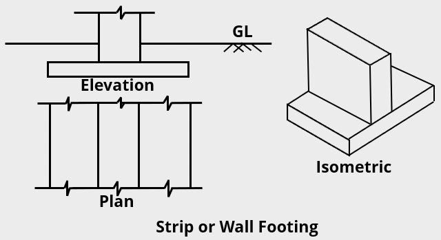
Strip or Wall Footing

Strip or Wall Footing

Isolated or Spread Footing

Isolated or Spread footing used in Civil Engineering constructions

Combined Footing

Combined footing used in Civil Engineering constructions

Strap or Cantilever Footing

Strap footing or cantilever footing

Mat or Raft Foundation

Types of Mat or Raft Foundation

Deep Foundation

A deep foundation is one whose width is less than its depth i.e. Df/B>1. Such a foundation transmits the load to the strata at a considerable depth below the surface of the earth & is provided to the heavyweight structure. It is preferred when the soil at the surface of the earth does not possess a considerable bearing capacity. The most common types of deep foundations are piles, piers & caissons. Well foundations are the special case of open caissons.
Types of deep foundation used in civil engineering constructions
What are the Criteria for Selection of Ideal Bridge Site?

What are the Criteria for Selection of Ideal Bridge Site?

Criteria for selection of ideal bridge site
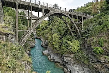
It is necessary to select an ideal bridge site at which the bridge can be made economically. As construction of a bridge requires a heavy investment, the bridge site should be selected wisely. A poor bridge site may increase the project's cost, making it susceptible to damage, in the long run, thus decreasing the life span of bridges. Thus, the following are the factors that require attention while selecting a bridge site.